

Aztec Drills 1.08 gpt Au and 30.23 gpt Ag (1.63 gpt AuEq) over 155.4 meters, Expands Oxide Gold-Silver Zone at Tombstone Project, Arizona
- Step-Out Drilling Continues to Expand the Contention Zone of Oxide Au/Ag Mineralization along Strike and at Depth
- Drill holes TR26-20 to TR26-30 have encountered multiple mineralized zones including an intersection of 155.4 m averaging 1.08 gpt Au and 30.23 gpt Ag (1.63 gpt AuEq) within 198.1 m averaging 0.86 gpt Au and 24.52 gpt Ag (1.30 gpt AuEq) in the Contention target area and other intersections on first pass test holes in the southwest and south of the Tombstone Property
Vancouver, British Columbia – July 15, 2026 - Aztec Minerals Corp. (AZT: TSX-V, OTCQB: AZZTF) (“Aztec” or the “Company”) announces the results from 11 drill holes (TR26-20 to TR26-30) from its reverse circulation (“RC”) portion of the 2025-2026 drilling program at the Tombstone Property in Southeastern Arizona. Step-out and first pass drilling has extended mineralization to the west, southwest and south of previously reported holes, and drilling in the central Contention area confirmed broad continuity of the mineralized zone and extended the oxide mineralization significantly to depth.
Aztec Minerals CEO Simon Dyakowski commented: “Our expanded drill program continues to demonstrate significant growth of the near-surface oxide gold-silver mineralized zone at Tombstone. We are now aggressively testing the North End area target. Drilling in the Contention zone continues to demonstrate consistently strong oxide gold and silver grades at shallow depths. The most recent drilling of the 21,000 meter 2025-2026 program has been successful in significantly expanding the Contention oxide mineralization vertically to depth as well as identifying new targets at Hard Up and Independence, immediately to the west, and at East Grand Central within the property.”
Highlights from the RC drilling reported for the Tombstone Property include:
- Hole TR26-30 intersected 198.1 m averaging 0.86 gpt Au and 24.52 gpt Ag (1.30 gpt AuEq) from surface to 198.1 m, approximately 98% of the drilled length, including 155.4 m averaging 1.08 gpt Au and 30.23 gpt Ag (1.63 gpt AuEq) from 6.1 m, which includes 44.2 m averaging 1.50 gpt Au and 60.51 gpt Ag (2.60 gpt AuEq) from 56.4 m and 6.1 m averaging 9.54 gpt Au and 35.03 gpt Ag (10.18 gpt AuEq) from 121.9 m.
- TR26-30 was collared in the central portion of the Contention pit adjacent to TR21-20 and fanned below it at -70 to a depth of 201.2m, and 45m east of TR21-17, reaching over 85m deeper vertically than TR21-20. The mineralized zone, hosted in hornfels, hydrothermal breccias and quartzites cut by quartz feldspar porphyry dikes, demonstrates continuity of oxidized mineralization between those holes and extends it vertically to depth in this portion of the Contention mineralization by 85 m, more than doubling the previously demonstrated depth.
- Hole TR26-21 in the Independence Mine Target Area intersected 18.3 m averaging 0.05 gpt Au and 19.03 gpt Ag (0.39 gpt AuEq) from 18.3 m, including 4.6 m of 58.60 gpt Ag from 19.8 m.
- Also at the Independence Mine, TR26-20 intersected 21.3 m averaging 0.08 gpt Au and 9.04 gpt Ag (0.24 gpt AuEq) from 51.8 m, including 4.6 m of 23.37 gpt Ag. Together these holes step out up to approximately 300 m west of previously reported drilling.
- Hole TR26-28 was collared in the southern portion of the Contention pit, just east of the Grand Central pit, 50m east-southeast from TR25-32. It was drilled at 196 Az, -70 to test observed surface mineralization. The drill hole intersected three zones in the quartzites and hornfels, the strongest being 19.8 m averaging 0.20 gpt Au and 20.28 gpt Ag (0.57 gpt AuEq) from 199.6 m, including 10.7 m averaging 0.34 gpt Au and 33.50 gpt Ag (0.95 gpt AuEq) from 208.7 m.
- Higher and adjacent in the drill hole, TR26-28 intersected 35.1 m averaging 0.04 gpt Au and 5.33 gpt Ag (0.13 gpt AuEq) from 155.4 m, and below at 239.3 m, 3.0 m averaging 0.05 gpt Au and 4.1 gpt Ag (0.13 gpt AuEq). This mineralization could lead to a larger discovery on the east side of the Contention zone.
- Hole TR26-23 in the Hard Up area to the southwest intersected 22.9 m averaging 0.13 gpt Au and 13.04 gpt Ag (0.37 gpt AuEq) from 16.8 m.
- Hole TR26-26 was collared in the southern portion of the Contention pit, just east of the Grand Central pit, 100m east-southeast from the South Spoke. It was drilled at 276 Az, -65 to test observed surface mineralization. The drill hole intersected two zones in the quartzites and hornfels, the strongest being 10.6 m averaging 0.34 gpt Au and 19.36 gpt Ag (0.70 gpt AuEq) from 125.0 m. Higher in the drill hole, TR26-26 intersected 4.5 m averaging 0.16 gpt Au and 18.2 gpt Ag (0.49 gpt AuEq) from 13.7 m.
The Company also reports the first assay results from the core drilling program: core holes TC25-01, TC25-02, TC25-03 and TC25-04:
- First core program results: core hole TC25-03 returned two zones of CRD sulfide mineralization: 4.6 m averaging 0.16 gpt AuEq, 0.44% Pb and 0.28% Zn from 379.5 m, and 4.6 m averaging 0.69 gpt AuEq, 0.21% Pb and 0.02% Zn from 545.6 m at the historic T-8 CRD target horizon. TC25-04 returned 32.0 m averaging 0.26 gpt AuEq from 336.8 m within the retrograde skarn zone, including 3.0 m averaging 0.58% Pb and 35.50 gpt Ag (see Table 1A).
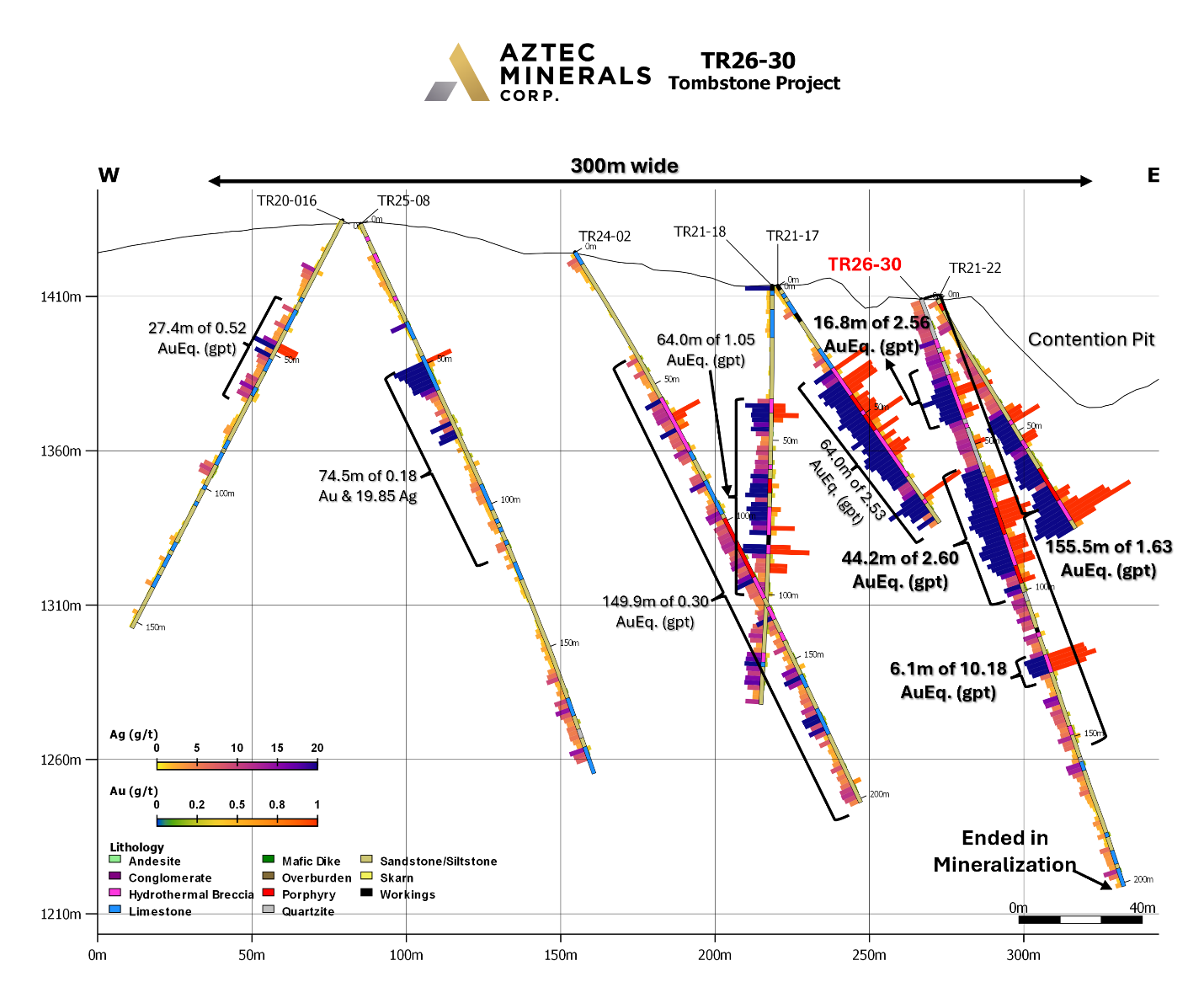
Figure 1. Cross section of RC drill hole TR26-30 showing Au and Ag assay results.
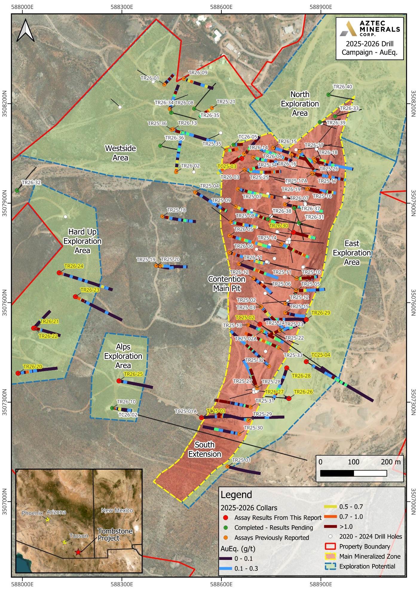
Figure 2. Plan map showing drill hole collars from the 2025-2026 drill campaign at the Tombstone Property, southeastern Arizona.
View drill sections here:
Link to section view hole TR26-20
Link to section view hole TR26-21
Link to section view hole TR26-22
Link to section view hole TR26-23
Link to section view hole TR26-24
Link to section view hole TR26-26 & TR26-27
Link to section view hole TR26-28
Link to section view hole TR26-29
Link to section view hole TR26-30
Table 1A: Drill Results Currently Reported
| Drill Hole | From (m) | To (m) | Interval (m)* | Au (gpt) | Ag (gpt) | AuEq (gpt) | Comments |
|---|---|---|---|---|---|---|---|
| TR26-20 | 51.8 | 73.1 | 21.3 | 0.08 | 9.04 | 0.24 | Independence Mine |
| Including | 51.8 | 56.4 | 4.6 | 0.24 | 23.37 | 0.67 | |
| and | 94.5 | 100.6 | 6.1 | 0.03 | 7.98 | 0.18 | |
| TR26-21 | 18.3 | 36.6 | 18.3 | 0.05 | 19.03 | 0.39 | Independence Mine |
| Including | 19.8 | 24.4 | 4.6 | 0.06 | 58.60 | 1.13 | |
| TR26-22 | 0.0 | 4.6 | 4.6 | 0.09 | 4.23 | 0.17 | Independence Mine |
| and | 44.2 | 48.8 | 4.6 | 0.08 | 4.67 | 0.16 | |
| TR26-23 | 16.8 | 39.7 | 22.9 | 0.13 | 13.04 | 0.37 | Hard Up |
| and | 59.4 | 64.0 | 4.6 | 0.04 | 3.73 | 0.10 | |
| and | 147.8 | 150.8 | 3.0 | 0.12 | 1.70 | 0.15 | |
| TR26-24 | 12.2 | 19.8 | 7.6 | 0.06 | 15.46 | 0.34 | Hard Up |
| and | 114.3 | 121.9 | 7.6 | 0.07 | 6.12 | 0.18 | |
| and | 242.3 | 257.5 | 15.2 | 0.04 | 7.86 | 0.18 | |
| and | 275.8 | 278.8 | 3.0 | 0.16 | 1.85 | 0.19 | |
| TR26-25 | No results with values of interest | ||||||
| TR26-26 | 13.7 | 18.3 | 4.6 | 0.16 | 18.2 | 0.49 | East side Grand Central Pit |
| and | 125.0 | 135.6 | 10.6 | 0.34 | 19.36 | 0.70 | |
| TR26-27 | No results with values of interest | ||||||
| TR26-28 | 155.4 | 190.5 | 35.1 | 0.04 | 5.33 | 0.13 | East side Grand Central Pit |
| and | 199.6 | 219.4 | 19.8 | 0.20 | 20.28 | 0.57 | |
| Including | 208.8 | 219.4 | 10.7 | 0.34 | 33.50 | 0.95 | |
| and | 239.3 | 242.3 | 3.0 | 0.05 | 4.10 | 0.13 | |
| TR26-29 | 131.1 | 160.1 | 29.0 | 0.10 | 8.84 | 0.26 | Eastern side of the Little Joe area |
| Including | 144.8 | 149.4 | 4.6 | 0.44 | 28.10 | 0.95 | |
| and | 175.3 | 179.9 | 4.6 | 0.14 | 8.60 | 0.30 | |
| TR26-30 | 0.0 | 198.1 | 198.1 | 0.86 | 24.52 | 1.30 | Working @ 112.8-114.3 m, no sample; 1.5 m excluded from interval |
| Including | 6.1 | 161.5 | 155.4 | 1.08 | 30.23 | 1.63 | |
| Including | 24.4 | 41.2 | 16.8 | 1.51 | 58.04 | 2.56 | |
| Including | 56.4 | 100.6 | 44.2 | 1.50 | 60.51 | 2.60 | |
| Including | 121.9 | 128.0 | 6.1 | 9.54 | 35.03 | 10.18 | |
| Core | |||||||
| TC25-01 | 256.0 | 268.2 | 12.2 | 0.01 | 4.70 | 0.10 | South AMT target |
| TC25-02 | 341.7 | 344.7 | 3.0 | 0.03 | 10.60 | 0.23 | South AMT target |
| TC25-03 | 183.5 | 193.6 | 10.1 | 0.16 | 12.72 | 0.39 | North CRD target |
| and | 202.7 | 207.3 | 4.6 | 0.08 | 5.57 | 0.18 | |
| and | 213.4 | 225.6 | 12.2 | 0.04 | 14.20 | 0.30 | |
| and | 379.5 | 384.1 | 4.6 | 0.06 | 5.5 | 0.16 | CRD – 0.44 Pb, 0.28 Zn |
| and | 545.6 | 550.2 | 4.6 | 0.64 | 2.65 | 0.69 | T-8 CRD target horizon-0.21 Pb, 0.02 Zn |
| TC25-04 | 303.3 | 309.4 | 6.1 | 0.04 | 3.93 | 0.11 | South AMT target |
| and | 317.0 | 323.1 | 6.1 | 0.03 | 4.53 | 0.12 | |
| and | 336.8 | 368.8 | 32.0 | 0.08 | 9.96 | 0.26 | 0.15 Pb, 0.12 Zn |
| Including | 338.3 | 341.3 | 3.0 | 0.53 | 35.50 | 1.18 | 0.58 Pb, 0.24 Zn |
| and | 393.2 | 399.3 | 6.1 | 0.09 | 8.25 | 0.24 | |
| and | 495.3 | 498.3 | 3.0 | 0.13 | 8.55 | 0.29 |
Note 1: Gold and Silver equivalents are calculated using the recovery percentages from third party metallurgical testing of RC drill pulps completed January 21, 2026 (81.5% for Au and 75.9% for Ag) and the average prices from January 1, 2026 to May 1, 2026 (US$4,817/oz Au, US$81.36/oz Ag), a price ratio of 59.2:1. Adjusted for the difference in metal recoveries, a 55:1 silver:gold ratio was used for the holes reported in this release. AuEq has been reported at 70:1 for November 2025 to February 2026, 90:1 in 2025 prior to November, 80:1 in 2023 and 2024, and a 70:1 silver:gold ratio in 2021.
2025-2026 Drill Program
The 84 RC drill holes completed to date in the current 2025-26 program are primarily part of a “fan grid pattern” being drilled in the Contention zone. Most of the RC drill holes are oriented to test for extensions on the western, eastern borders, the southern extensions, and underneath the north-trending main Contention target zone which hosts the historic underground and open pit Contention mine. Several RC drill holes tested targets in the Westside and Hard Up areas on projected anticline, dike and fissure vein intersections under mineralized outcrops and historic shafts. The drill program has continued to identify to depth and horizontally pervasively oxidized and hematite-rich, silicified hydrothermal breccias composed of quartz feldspar porphyry dike and Bisbee Group clastic sedimentary fragments, typical of the material mined historically at the Contention Mine.
Additional mineralization types continued to be outlined by the current drilling including: manganese replacements in limestone beds and skarns, quartz veinlets, oxidized sulfide relicts as disseminations, silicification of altered hornfels, quartz feldspar porphyries and hydrothermal breccias.
The primary objectives of the 2025-26 drilling program were to: Expand the known mineralization horizontally to the west, north and south, and down dip beyond the holes drilled by Aztec in 2020-24 at the Contention Pit with step outs to enlarge the shallow, broad, bulk tonnage gold-silver mineralization discovered there; test by core drilling the initial deep CRD targets and also, to explore with first pass drilling new targets identified in the Westside area. The drilling results showed that the Contention area mineralization is still open at depth and the mineralized volume is expanding.
Table 1B: Tombstone 2026 Reported Results
| Drill Hole | From (m) | To (m) | Interval (m)* | Au (gpt) | Ag (gpt) | Au Eq (gpt) (1) | Comments |
|---|---|---|---|---|---|---|---|
| TR26-01 | 51.7 | 72.9 | 21.3 | 0.038 | 11.76 | 0.208 | Working 71.4 – 73.0 m no sample |
| 86.6 | 110.9 | 24.3 | 0.039 | 13.37 | 0.230 | Last 4 samples in working, no recovery | |
| TR26-02 | 0.0 | 19.8 | 19.8 | 0.136 | 12.62 | 0.316 | |
| 54.7 | 60.8 | 6.1 | 0.088 | 13.67 | 0.284 | ||
| 91.2 | 100.3 | 9.1 | 0.094 | 5.65 | 0.175 | ||
| 130.7 | 147.4 | 16.7 | 0.076 | 2.76 | 0.115 | ||
| TR26-03 | 147.4 | 161.1 | 13.7 | 0.069 | 3.73 | 0.122 | |
| 167.2 | 177.8 | 10.6 | 0.103 | 7.21 | 0.206 | ||
| 193.0 | 205.2 | 12.2 | 0.149 | 8.7 | 0.273 | ||
| TR26-04 | 53.2 | 63.8 | 10.6 | 0.057 | 8.17 | 0.173 | |
| 147.4 | 161.1 | 13.7 | 0.040 | 4.16 | 0.1 | ||
| 168.7 | 188.5 | 19.8 | 0.220 | 13.75 | 0.416 | ||
| TR26-05 | 16.7 | 36.5 | 19.8 | 0.223 | 8.78 | 0.358 | |
| 60.8 | 73.0 | 12.2 | 0.117 | 3.85 | 0.172 | ||
| 80.6 | 130.7 | 50.2 | 0.112 | 4.90 | 0.182 | ||
| 136.8 | 158.1 | 21.3 | 0.117 | 11.44 | 0.280 | ||
| 165.7 | 174.8 | 9.1 | 0.086 | 4.65 | 0.152 | ||
| 182.4 | 217.4 | 35.0 | 0.119 | 5.95 | 0.204 | ||
| 231.0 | 255.3 | 24.3 | 0.091 | 3.6 | 0.142 | TD in minz | |
| TR26-06 | 31.9 | 47.1 | 15.2 | 0.124 | 4.06 | 0.182 | |
| 62.3 | 69.9 | 7.6 | 0.223 | 11.66 | 0.390 | ||
| 88.2 | 120.1 | 31.9 | 0.159 | 3.86 | 0.214 | ||
| 130.7 | 158.1 | 27.4 | 0.057 | 29.22 | 0.474 | ||
| 202.2 | 261.5 | 59.3 | 0.104 | 4.96 | 0.175 | TD in minz | |
| TR26-07 | 50.2 | 162.6 | 112.4 | 0.479 | 12.64 | 0.659 | Working 59.3 to 62.3 m |
| 173.2 | 185.4 | 12.2 | 0.127 | 8.11 | 0.243 | ||
| 221.9 | 238.6 | 16.7 | 0.049 | 7.49 | 0.156 | TD in minz | |
| TR26-08 | 121.6 | 129.2 | 7.6 | 0.576 | 8.4 | 0.696 | |
| TR26-09 | 35.0 | 45.6 | 10.6 | 0.069 | 9.06 | 0.199 | |
| 53.2 | 59.3 | 6.1 | 0.181 | 13.1 | 0.367 | ||
| 158.1 | 164.1 | 6.1 | 0.041 | 7.37 | 0.147 | ||
| TR26-10 PC | 112.5 | 118.6 | 6.1 | 0.162 | 9.15 | 0.293 | |
| TR26-11 | 100.3 | 200.6 | 100.3 | 0.173 | 11.46 | 0.337 | |
| TR26-12 | 100.3 | 149.0 | 48.6 | 0.172 | 18.04 | 0.430 | |
| TR26-13 | 18.2 | 27.4 | 9.1 | 0.056 | 8.27 | 0.174 | |
| 63.8 | 68.8 | 4.6 | 0.132 | 3.33 | 0.180 | ||
| 85.1 | 91.2 | 6.1 | 0.039 | 5.00 | 0.110 | ||
| 194.5 | 200.6 | 6.1 | 0.062 | 4.275 | 0.123 | ||
| TR26-14 | 0.0 | 10.6 | 10.6 | 0.195 | 13.00 | 0.381 | |
| 39.5 | 147.4 | 107.9 | 0.618 | 24.80 | 0.972 | ||
| 176.3 | 225.0 | 48.6 | 0.091 | 8.11 | 0.206 | ||
| 234.1 | 243.2 | 9.1 | 0.121 | 10.67 | 0.267 | TD in minz | |
| TR26-15 | 92.7 | 139.8 | 47.1 | 0.214 | 13.26 | 0.456 | |
| 156.6 | 200.6 | 42.6 | 0.096 | 3.42 | 0.157 | TD in minz | |
| TR26-16 | 57.9 | 147.8 | 89.8 | 0.223 | 10.96 | 0.423 | |
| 164.6 | 179.8 | 15.24 | 0.069 | 5.68 | 0.157 | ||
| 195.0 | 198.1 | 3.1 | 0.077 | 5.7 | 0.181 | TD in minz | |
| TR26-17 | 62.5 | 67.1 | 4.6 | 0.613 | 2.13 | 0.651 | |
| 82.3 | 204.2 | 121.9 | 0.294 | 11.3 | 0.499 | TD in minz, workings @ 111.2-114.3 m, 118.9-121.9 m | |
| Including | 85.3 | 97.5 | 12.2 | 1.017 | 14.54 | 1.281 | |
| TR26-18 | 0.0 | 53.2 | 53.2 | 0.775 | 31.94 | 1.356 | |
| Including | 25.8 | 44.1 | 18.2 | 1.909 | 79.07 | 3.346 | |
| 79.0 | 100.3 | 21.3 | 0.132 | 4.41 | 0.212 | ||
| 111.0 | 164.2 | 53.2 | 0.084 | 6.246 | 0.198 | ||
| TR26-19 | 13.7 | 80.6 | 66.9 | 1.050 | 23.21 | 1.472 | |
| Including | 30.4 | 57.8 | 27.4 | 2.309 | 43.23 | 3.095 | |
| 88.2 | 107.9 | 19.8 | 0.162 | 6.68 | 0.283 | ||
| 114.0 | 135.3 | 21.3 | 0.395 | 12.37 | 0.620 | ||
| 142.9 | 167.2 | 24.3 | 0.092 | 7.14 | 0.221 | ||
| 174.8 | 199.1 | 24.3 | 0.105 | 10.0 | 0.286 | TD in minz |
Table 2 – 2026 Drillhole Coordinates
| Drill Hole | UTM East | UTM North | Azimuth | Inclination | Total Depth (m) |
|---|---|---|---|---|---|
| TR26-20 | 587987 | 3507387 | 84 | -59 | 219.5 |
| TR26-21 | 588038 | 3507523 | 106 | -60 | 146.4 |
| TR26-22 | 588034 | 3507523 | 43 | -44 | 91.4 |
| TR26-23 | 588160 | 3507618 | 118 | -49 | 213.4 |
| TR26-24 | 588111 | 3507690 | 108 | -58 | 304.8 |
| TR26-25 | 588291 | 3507364 | 101 | -61 | 201.2 |
| TR26-26 | 588803 | 3507311 | 276 | -65 | 152.4 |
| TR26-27 | 588804 | 3507311 | 282 | -85 | 91.4 |
| TR26-28 | 588797 | 3507403 | 196 | -70 | 254.5 |
| TR26-29 | 588856 | 3507549 | 272 | -60 | 243.8 |
| TR26-30 | 588817 | 3507812 | 104 | -70 | 201.2 |
| TC25-01 | 588540 | 3507253 | 90 | -64 | 373.4 |
| TC25-02 | 588716 | 3507534 | 125 | -60 | 348.4 |
| TC25-03 | 588661 | 3508034 | 75 | -83 | 691.0 |
| TC25-04 | 588856 | 3507422 | 123 | -75 | 831.5 |
| TC26-05 | 588637 | 3508076 | 88 | -82 | 700.1 |
Core Drilling Update
The core drilling portion of the program in 2026 drilled five core holes on the Southwest AMT anomaly (TC26-02), the T-8 CRD target (TC26-05) in the north following up on a downhole EM survey of TC25-03, general exploration (TC26-01, 04) and metallurgical (TC26-03) holes. Nine core holes (TC25-01, 02, 03, 04 and TC26-01, 02, 03, 04, 05) have been attempted in 2025-2026. Core hole TC26-02 is the deepest in the program, drilled to 862m.
The core drilling program was designed to test the deep targets of the Project comprising the targeting of the large, southern and southwestern NSAMT targets and the historic T-8 drillhole CRD intercept, with some metallurgical core sample collection as well.
A synopsis for the core drilling follows:
- Drill hole TC26-05 was a follow up to a downhole EM survey of TC25-03 which targeted the historic T-8 CRD intercept in the northern portion of the Project. The drill hole was oriented 90 azimuth, -83, initially had RC pre-collar of 600 ft (182.9m) that intercepted zones of oxide mineralization. The core drill hole reached a depth of 700.1m. This entire zone is associated with notable argillic and occasional silicic alterations to 2297 ft (700.1m) depth. It is considered that significant CRD mineralization should be nearby due to the strong presence of argillic alteration. Final geochemical analytical results for this drill hole are pending.
- Drill hole TC25-03 targeted the historic T-8 CRD intercept in the northern portion of the Project. A high angle drill hole first had pre-collar of 600 ft (182.9m) that intercepted two zones of oxide mineralization and penetrated a historic mine working within 0.5m – 1.0m of estimated depth. The drill hole reached a depth of 690.9m, and it was in the stable Paleozoic carbonates from 228.6m depth onwards. Oxidation stopped by 320.1m. Three moderate to minor intensity zones of CRD mineralization were found at 1255-1275 ft (382.6-388.7m), 1350-65 ft (411.6-416.1m), and 1790 -1810 ft (545.7-551.8m). This later depth is equivalent to that of the T-8 CRD mineralization. This entire zone is associated with notable argillic and occasional silicic alterations to 1950 ft (594.5m) depth. Assay results returned 4.6 m averaging 0.64 gpt Au and 2.65 gpt Ag with approximately 0.2% Pb from 545.6 m, within the T-8 target horizon, together with three shallower zones between 183.5 m and 225.6 m grading up to 0.39 gpt AuEq. Individual samples returned up to 1.00% Zn with 35.3 gpt Ag (213.4 m - 214.9 m) and 0.59% Pb (548.6 m - 550.2 m) at the T-8 horizon.
- Drill hole TC25-04 targeted the southern NSAMT target by drilling from above at a high angle after a 91.4m pre-collar was made in the Lower Bisbee Formation sediments. While the drilling was difficult, steady advances were made and the drill hole reached a depth of 831.5m before being lost to caving. The NSAMT target was estimated prior to drilling to start at 503.0m depth while the potential NSAMT anomaly retrograde skarn zone was found lower in depth 579.3m. TC25-04 encountered mild to moderate strength retrograde exoskarns in the hornfels of the lower Cretaceous basal Bisbee siliciclastic sediments at 579.3 m depth and it continued for the rest of the drillhole. The skarns are typified by epidote and chlorite with associated hematite staining. The skarns are accompanied by several silicified hydrothermal breccia dikes with occasional Qfp clasts and with evidence of potential “B-type” porphyry veinlets over that thickness. The hydrothermal breccia (Hbx) dikes with occasional Qfp clasts within them were intercepted from 354.3m to 728.7m. It was notable that the oxidation was considerably deeper than found elsewhere in the Project with Sulfides starting to appear at 643m. The contact with underlying Paleozoic carbonates is also considerably deeper compared to the north CRD target area, finding the Naco Limestone at 778.9m. It is interpreted that the retrograde skarns and Hbx dikes are the origin of the AMT anomaly but there should be a source porphyry intrusive not too far away. Assay results returned six zones between 303.3 m and 498.3 m, the strongest being 32.0 m averaging 0.08 gpt Au and 9.96 gpt Ag (0.26 gpt AuEq) from 336.8 m within the retrograde skarn zone, including 3.0 m averaging 0.53 gpt Au and 35.50 gpt Ag.
- Drillhole TC26-01 targeted the western, downdip extension of the Contention/Grand Central system but was stopped due to difficult ground conditions for drilling and the drill moved to next pre-collar just being finished. The drillhole had a depth of 53.6m with only minor mineralization.
- Drillhole TC26-02 targeted the southern NSAMT target by drilling towards the east for a depth of 861.7m. The ground rock was the Lower Bisbee Formation until 705.8m when the Paleozoic carbonates were intersected. As the contact is at about 200 meters higher than in TC25-04, the interpretation is that this reflects the Contention fault system dropping its eastern side. The NSAMT anomaly targeted is probably a response to the retrograde skarn found starting at 332.2m depth. Traces of galena were found at 771.3m, as well as a Hbx dike at 414.6m, noting that the oxidation ended at 478.6m. It is interpreted that the retrograde skarns and Hbx dikes are the origin of the AMT anomaly but there could be a source porphyry intrusive in close proximity, perhaps <500m. Final geochemical analytical results for this drill hole are pending.
- Drillhole TC26-03 was drilled on the western side of the central portion of the Contention pit towards the east. It was designed as a metallurgical sample hole in the Lower Bisbee Formation and stopped at 176.6m due to adverse ground conditions before reaching the target Qfp dike. One mineralized Qfp/Hbx dike was traversed at 285-320 ft (86.9-97.6m) while much of the drillhole had argillic alteration, strong Fe oxides and the presence of quartz veinlets, which are positive indications of potential precious metal mineralization. Final geochemical analytical results for this drill hole are pending.
- Drillhole TC26-04 was drilled on the far west side of the central portion of the known Contention system. It was designed as a fan to TR25-09 to demonstrate the western, down-dip extension of the Contention system at depth. Final geochemical analytical results for this drill hole are pending.
- Drill hole TC25-01 targeted the southern AMT target by drilling from west to easterly across the Contention system and reached 1225 ft (373.4m). It was stopped due to difficult ground conditions in fractured and faulted Bisbee Formation rock after a 182.9m pre-collar was completed. Assay results returned one zone of 12.2 m averaging 0.01 gpt Au and 4.70 gpt Ag (0.10 gpt AuEq) from 256.0 m.
- Drill hole TC25-02 targeted the southern AMT target from west to southeasterly across the Contention system and reached 1143 ft (348.4m). This drill hole also encountered difficult drilling conditions in the fractured and faulted Bisbee Formation after the 273.6m RC pre-collar. Assay results returned 3.0 m averaging 0.03 gpt Au and 10.60 gpt Ag from 341.7 m.
Core drilling to-date has confirmed the NSAMT targets as based on geologic (Skarn) anomalies within the upper portion of the NSAMT targets. It was planned to continue drilling to depth in TC25-04; however, drillhole caving terminated the hole. Aztec had previously identified several large, strong, conductive bodies, underneath the historic gold-silver project through NSAMT (natural-source audio-frequency magneto-telluric surveys) anomalies1.
The continued, successful drilling of the Contention pit area was supported by Aztec’s 3D geologic and underground workings model that was constructed to assist in targeting potential expansion of the Contention system. The overall Contention system has yet to be defined and marks the confluence of other mineralized zones including the Westside Anticline.
Drill samples are collected every 1.52 m from RC chips and every 1.5m from sawing the core drill holes. The samples are analyzed by Bureau Veritas for gold with a 30-gram sample size using the method FA430 followed by MA300. Bureau Veritas is independent of the Company and of the Qualified Person. Over limits, when present, are analyzed by MA370 or FA530. The Company uses quality assurance-quality control as a standard part of its sampling-assaying-assessments in conjunction with its exploration sampling programs. Samples and their collection are controlled by an industry standard conforming QAQC program including all drill holes containing certified blanks, standards, and duplicates. The samples are being regularly shipped to and received by the Bureau Veritas Minerals laboratory in Hermosillo, Mexico for geochemical analysis. The QAQC for the drilling programs has been evaluated and found to have good results.
Tombstone Project Overview
Aztec Minerals holds an 85.0% interest in the Tombstone Property Joint Venture, which includes most of the original patented mining claims in the main district as well as some recently acquired properties.
The main target of the current drilling is to continue testing the shallow, bulk tonnage, potentially heap leachable, mesothermal gold-silver oxide mineralization adjacent and below the previously mined Contention pit by step-out drilling. Future drilling is expected to focus on follow-up on the current program’s results. It is anticipated that possible targeting could include strike and dip extensions of the shallow oxide mineralization, and move along those trends deeper into the sulfide zone as historically there was significant production to 300 m depth*2.
The Tombstone project is located 100 kilometers (km) southeast of Tucson, Arizona and covers much of the historic Tombstone silver district. Tombstone is renowned for its high grade, oxidized, silver-gold mesothermal stringer lode veins, hydrothermal breccias and manto CRD orebodies that were mined in the late 1800’s and early 1900’s. The historic silver production in the Tombstone district from 1878 to 1939 was estimated at 32 million ounces and 250,000 ounces of gold*2.
The district geology consists of a mix of shallow-level, oxidized Au-Ag and base metal deposits related to CRD and skarns hosted in folded and thrusted sediments, intrusive dikes, and lode veins, and as well the under explored, sulfide versions located below the water table.
Host rocks to the mineralization are primarily the clastic sediments of the lowest portion of the Cretaceous Bisbee Formation. Between 50 and 300 meters (m) in depth, the Bisbee is underlain by approximately two kms thick of the same Paleozoic carbonate formations that host the Hermosa-Taylor zinc-lead-silver deposit of South32 located 60 km southwest of Tombstone.
Aztec believes that the historic silver mines at Tombstone could be related to a much larger mesothermal system with CRD mineralization below the old mines. Since 2017, Aztec has completed geological mapping, geochemical sampling and geophysical surveying to identify the most prospective areas for Au-Ag mineralization around and below the Contention open pit, and CRD zinc-lead-copper-silver-gold mineralization below the entire district. Aztec management views the district as highly prospective for the discovery of mesothermal and CRD mineralization.
Summary Tombstone Project Highlights
- Well located property on patented (46) and unpatented (73) claims (833.25 hectares/2,058.1 acres), covers much of the historic Tombstone silver mining district, great infrastructure, local town, road access, full services, water, power
- Historic silver district*2 produced 32 million ounces of silver and 250,000 ounces of gold from 1878-1939, in high grade, oxidized, silver-gold-lead-zinc-copper vein, breccia and CRD deposits, and small open pit heap leach production in late 1980’s
- Drilling by Aztec in 2020-26 has demonstrated that the Contention Pit target has significant, shallow, oxidized Au-Ag bulk tonnage mineralization which is open in all directions
- Multiple other prospective targets in Cretaceous and Paleozoic rocks related to major NW and NNE trending structures hosting porphyritic intrusions crosscutting a possible caldera ring structure
* Aztec has not verified these historic results and is not relying on them. Aztec has in its possession the historic drill logs, maps and reports but does not have any information on the quality assurance or quality control measures taken in connection with these historical exploration results.
Noted References:
1 – “Zonge International, AMT Survey, Tombstone Project, Cochise County, AZ, Data Acquisition and Processing Report, Prepared for Aztec Minerals, 18 May 2020, Zonge Job #20013”
2 – Greeley, Michael N., A Brief History and Review of Ore Grades and Production in the Tombstone Mining District with Emphasis on the Contention Mine Area, June 1984
The scientific and technical information contained in this news release has been reviewed and approved by Allen David Heyl, B.Sc., CPG – AIPG No.11277, VP Exploration of Aztec, a Qualified Person under NI43-101. Mr. Heyl supervises the Tombstone exploration programs. Mr. Heyl has verified the data, which included a review of the sampling, analytical and test methods underlying the data, information and opinions disclosed herein.
“Simon Dyakowski”
Simon Dyakowski, Chief Executive Officer
Aztec Minerals Corp.
About Aztec Minerals – Aztec is a mineral exploration company focused on two emerging discoveries in North America. The Cervantes project is an emerging porphyry gold-copper discovery in Sonora, Mexico. The Tombstone project is an emerging gold-silver discovery with high grade CRD silver-lead-zinc potential in southern Arizona. Aztec’s shares trade on the TSX-V stock exchange (symbol AZT) and on the OTCQB (symbol AZZTF).
Contact Information - For more information, please contact:
Simon Dyakowski, President & CEO, Director
Tel: (604) 685-9770
Fax: (604) 685-9744
Email: info@aztecminerals.com
Website: www.aztecminerals.com
Neither the TSXV nor its Regulation Services Provider (as that term is defined in the policies of the TSXV) accepts responsibility for the adequacy or accuracy of this release. No stock exchange, securities commission or other regulatory authority has approved or disapproved the information contained herein.
Forward-Looking Statements:
This news release contains “forward‐looking information or statements” within the meaning of applicable securities laws, which may include, without limitation, completing ongoing and planned work, statements relating to advancing the Tombstone Project, drill and sampling results including additional potential work and results therefrom, the Company’s plans for its Tombstone Project, potential for further expansion of the mineralization at the Tombstone Project, expected results and outcomes, the technical, financial and business prospects of the Company, its project and other matters. All statements in this news release, other than statements of historical facts, that address events or developments that the Company expects to occur, are forward-looking statements. Although the Company believes the expectations expressed in such forward-looking statements are based on reasonable assumptions, such statements are not guarantees of future performance and actual results may differ materially from those in the forward-looking statements. Such statements and information are based on numerous assumptions regarding present and future business strategies and the environment in which the Company will operate in the future, including the price of metals, the ability to achieve its goals, that general business and economic conditions will not change in a material adverse manner, that financing will be available if and when needed and on reasonable terms. Such forward-looking information reflects the Company’s views with respect to future events and is subject to risks, uncertainties and assumptions, including the risks and uncertainties relating to the interpretation of exploration results, risks related to the inherent uncertainty of exploration and cost estimates and the potential for unexpected costs and expenses, and those filed under the Company’s profile on SEDAR+ at www.sedarplus.ca. Factors that could cause actual results to differ materially from those in forward looking statements include, but are not limited to, continued availability of capital and financing and general economic, market or business conditions, adverse weather or climate conditions, failure to maintain or obtain all necessary government permits, approvals and authorizations, failure to obtain or maintain community acceptance (including First Nations), decrease in the price of gold, silver and other metals, increase in costs, litigation, and failure of counterparties to perform their contractual obligations. The Company does not undertake to update forward‐looking statements or forward‐looking information, except as required by law.