

Aztec Drills 88.4 meters of 1.42 g/t Au and 14.58 g/t Ag (1.69 g/t AuEq) in First North Extension Step-Out Drilling at the Tombstone Project, Arizona
- First Step-Out Drilling in Newly Acquired North Extension Zone has Expanded the Contention Zone of Oxide Au/Ag Mineralization to the North and at Depth
- Drill hole TR26-39, stepping out into the North Extension Zone, encountered multiple mineralized zones including an intersection of 88.4 m averaging 1.42 g/t Au and 14.58 g/t Ag (1.69 g/t AuEq) from 10.7 m.
- Contention Zone drillhole TR26-38 returned 97.5 m averaging 1.06 g/t Au and 16.08 g/t Ag (1.36 g/t AuEq) from surface.
Vancouver, British Columbia – August 5, 2026 - Aztec Minerals Corp. (AZT: TSX-V, OTCQB: AZZTF) (“Aztec” or the “Company”) announces results from nine reverse circulation (“RC”) drill holes, TR26-31 to TR26-39, at its Tombstone Property in southeastern Arizona. The holes include the first step-outs drilled into the recently acquired North Extension Zone, where TR26-33 and TR26-39 both intersected oxide gold-silver mineralization on ground not previously drilled by Aztec. TR26-39, one of the first two holes drilled into the North Extension Zone, returned 88.4 m averaging 1.42 g/t Au and 14.58 g/t Ag (1.69 g/t AuEq) from 10.7 m, and TR26-38 in the Contention Zone returned 97.5 m averaging 1.06 g/t Au and 16.08 g/t Ag (1.36 g/t AuEq) from surface.
Both intervals are the type of shallow, continuous oxide mineralization that Aztec is targeting at Contention — bulk tonnage material beginning at or near surface and potentially amenable to heap leaching. Each interval also carries a high-grade core, with 6.1 m averaging 12.23 g/t Au and 56.28 g/t Ag (13.25 g/t AuEq) in TR26-39 and 6.1 m averaging 12.17 g/t Au and 69.08 g/t Ag (13.43 g/t AuEq) in TR26-38. The near-surface oxide gold-silver zone remains open in all directions, including to the north and at depth.
Ninety RC holes have been completed in the 2025-2026 program as at the date of this release — forty in 2025 and fifty in 2026. Assay results are pending for the eleven most recent step-out holes, TR26-40 to TR26-50, which include first pass holes collared up to approximately 230 m north of TR26-39 along the trend of the North Extension Zone — the most northerly ground yet tested. Those results are expected in the coming weeks, and drilling is expected to continue through at least September 2026. Results from the holes reported in this release, together with those pending from TR26-40 to TR26-50, are expected to be incorporated into the Company’s previously announced maiden mineral resource estimate for the Tombstone Project.
Aztec Minerals CEO Simon Dyakowski commented: “The story in these holes is continuity. We are seeing thick oxide intervals starting at or near surface across the Contention area, and now we are seeing them in the North Extension on a first pass through ground we had not drilled before. That tells us the system is larger than the footprint we have defined to date. It remains open in all directions, including to the north and at depth, and with ninety RC holes completed and assays still pending, we expect to keep adding to it through the balance of the program.”
Highlights from the RC drilling reported for the Tombstone Property include:
- Hole TR26-39, a first pass hole in the North Extension Area, intersected 88.4 m averaging 1.42 g/t Au and 14.58 g/t Ag (1.69 g/t AuEq) from 10.7 m, including 6.1 m averaging 1.55 g/t Au and 4.53 g/t Ag (1.63 g/t AuEq) from 27.4 m and 12.2 m averaging 6.38 g/t Au and 33.93 g/t Ag (7.00 g/t AuEq) from 64.0 m, which includes 6.1 m averaging 12.23 g/t Au and 56.28 g/t Ag (13.25 g/t AuEq) from 65.5 m. The hole ended in mineralization, with 30.5 m averaging 0.18 g/t Au and 5.63 g/t Ag (0.28 g/t AuEq) from 146.3 m to the end of the hole, including 4.6 m averaging 0.56 g/t Au and 11.97 g/t Ag (0.78 g/t AuEq) from 169.2 m.
- Hole TR26-38 intersected 97.5 m averaging 1.06 g/t Au and 16.08 g/t Ag (1.36 g/t AuEq) from surface, including 18.3 m averaging 4.60 g/t Au and 52.49 g/t Ag (5.55 g/t AuEq) from 68.6 m, which includes 6.1 m averaging 12.17 g/t Au and 69.08 g/t Ag (13.43 g/t AuEq) from 79.2 m. A second zone beginning 7.7 m below returned 106.7 m averaging 0.10 g/t Au and 4.16 g/t Ag (0.17 g/t AuEq) from 105.2 m, giving near-continuous mineralization from surface to 211.8 m.
- Hole TR26-33, a first pass hole into the North Extension Area, intersected 13.7 m averaging 1.50 g/t Au and 23.56 g/t Ag (1.93 g/t AuEq) from 85.3 m, including 7.6 m averaging 2.64 g/t Au and 40.72 g/t Ag (3.38 g/t AuEq) from 88.4 m. The interval includes a historic working from 94.5 to 97.5 m. Four shallower zones were intersected starting at surface (see Table 1A).
- Hole TR26-31 intersected 21.3 m averaging 1.07 g/t Au and 28.42 g/t Ag (1.59 g/t AuEq) from 82.3 m, within a broader zone of 64.0 m averaging 0.42 g/t Au and 13.54 g/t Ag (0.67 g/t AuEq) from 65.5 m. An upper zone returned 10.7 m averaging 0.39 g/t Au and 2.73 g/t Ag (0.44 g/t AuEq) from 21.3 m, and three deeper zones were intersected between 141.7 m and 185.9 m (see Table 1A).
- Hole TR26-37 intersected 79.2 m averaging 0.26 g/t Au and 8.88 g/t Ag (0.42 g/t AuEq) from 45.7 m, including 3.0 m averaging 0.86 g/t Au and 22.70 g/t Ag (1.27 g/t AuEq) from 85.3 m and 6.1 m averaging 0.59 g/t Au and 15.58 g/t Ag (0.88 g/t AuEq) from 100.6 m. An upper zone returned 6.1 m averaging 0.13 g/t Au and 3.43 g/t Ag (0.19 g/t AuEq) from 16.8 m. Four additional zones were intersected between 131.1 m and 205.7 m (see Table 1A).
- Holes TR26-34, TR26-35 and TR26-36, all drilled in the Westside Exploration Area, each intersected multiple mineralized zones, the strongest being 25.9 m averaging 0.19 g/t Au and 11.95 g/t Ag (0.41 g/t AuEq) from 44.2 m in TR26-34, including 9.1 m averaging 0.49 g/t Au and 20.05 g/t Ag (0.85 g/t AuEq); 22.9 m averaging 0.12 g/t Au and 10.61 g/t Ag (0.31 g/t AuEq) from 83.8 m in TR26-35; and 32.0 m averaging 0.13 g/t Au and 12.50 g/t Ag (0.36 g/t AuEq) from 91.4 m in TR26-36, including 4.6 m averaging 0.55 g/t Au and 26.37 g/t Ag (1.03 g/t AuEq). These drill holes demonstrate continued resource potential of the Westside Exploration Area (see Figure 1 and Table 1A).
- Hole TR26-32, drilled in the Ingersol anticline area approximately 800 m west of the Contention pit, returned no results with values of interest.
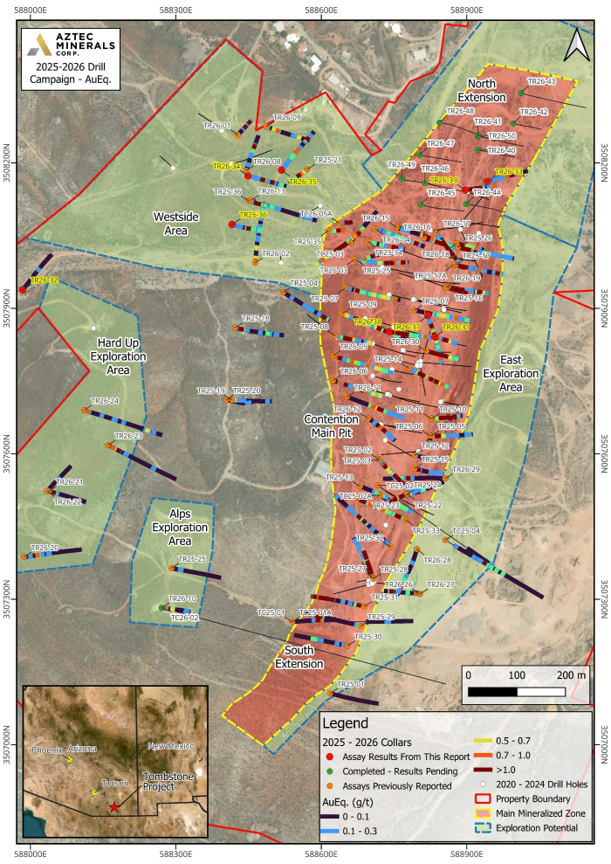
Figure 1. Plan map showing drill hole collars with Au Eq. (g/t) values from the 2025-2026 drill campaign at the Tombstone Property, southeastern Arizona. Holes reported in this release are shown in red; completed holes with assay results pending, including the eleven North Extension step-outs, are shown in green. Previously reported holes are shown in orange and 2020-2024 drill holes in white.
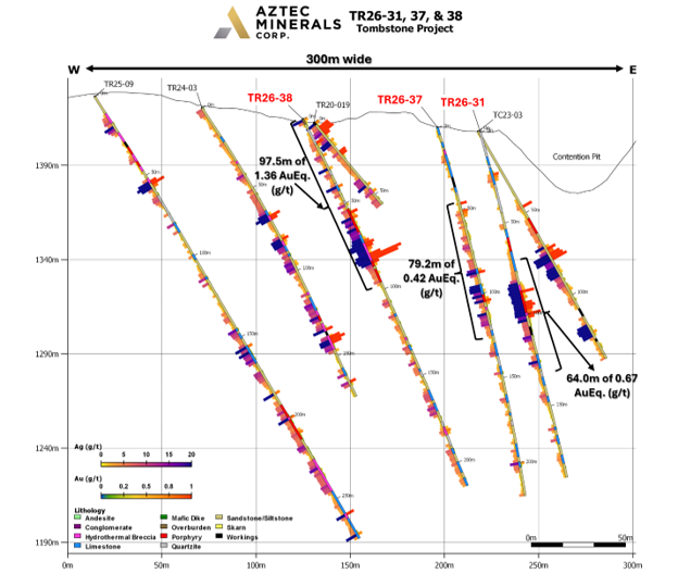
Figure 2. Cross section of RC drill holes TR26-31, 37 and 38 showing Au and Ag assay results.
View drill sections here:
Link to section view hole TR26-31, TR26-37, TR26-38
Link to section view hole TR26-33 and TR26-39
Link to section view hole TR26-32
Link to section view hole TR26-34
Link to section view hole TR26-35
Link to section view hole TR26-36
Table 1A: Drill Results Currently Reported
| Drill Hole | From (m) | To (m) | Interval (m) | Au (g/t) | Ag (g/t) | AuEq (g/t) | Comments |
|---|---|---|---|---|---|---|---|
| TR26-31 | 21.3 | 32.0 | 10.7 | 0.39 | 2.73 | 0.44 | |
| and | 65.5 | 129.5 | 64.0 | 0.42 | 13.54 | 0.67 | |
| Including | 82.3 | 103.6 | 21.3 | 1.07 | 28.42 | 1.59 | |
| and | 141.7 | 147.8 | 6.1 | 0.06 | 5.95 | 0.17 | |
| and | 161.5 | 169.2 | 7.6 | 0.07 | 4.12 | 0.14 | |
| and | 176.8 | 185.9 | 9.1 | 0.06 | 2.77 | 0.11 | |
| TR26-32 | No results with values of interest | ||||||
| TR26-33 | 0.0 | 7.6 | 7.6 | 0.19 | 11.76 | 0.41 | North Extension Area |
| and | 24.4 | 30.5 | 6.1 | 0.10 | 1.18 | 0.12 | |
| and | 39.6 | 42.7 | 3.0 | 0.04 | 4.55 | 0.12 | |
| and | 70.1 | 77.7 | 7.6 | 0.30 | 8.88 | 0.46 | |
| and | 85.3 | 99.1 | 13.7 | 1.50 | 23.56 | 1.93 | Working @ 94.5-97.5 m |
| Including | 88.4 | 96.0 | 7.6 | 2.64 | 40.72 | 3.38 | |
| TR26-34 | 1.5 | 7.6 | 6.1 | 0.09 | 5.35 | 0.19 | |
| and | 44.2 | 70.1 | 25.9 | 0.19 | 11.95 | 0.41 | |
| Including | 59.4 | 68.6 | 9.1 | 0.49 | 20.05 | 0.85 | |
| and | 82.3 | 86.9 | 4.6 | 0.04 | 5.67 | 0.14 | Working @ 85.3-89.9 m |
| and | 102.1 | 112.8 | 10.7 | 0.07 | 10.50 | 0.26 | |
| and | 135.6 | 146.3 | 10.7 | 0.08 | 5.37 | 0.17 | |
| TR26-35 | 62.5 | 77.7 | 15.2 | 0.07 | 6.57 | 0.19 | |
| and | 83.8 | 106.7 | 22.9 | 0.12 | 10.61 | 0.31 | |
| Including | 97.5 | 100.6 | 3.0 | 0.18 | 35.40 | 0.82 | |
| and | 158.5 | 182.9 | 24.4 | 0.10 | 7.51 | 0.23 | |
| TR26-36 | 45.7 | 54.9 | 9.1 | 0.04 | 3.70 | 0.11 | |
| and | 91.4 | 123.4 | 32.0 | 0.13 | 12.50 | 0.36 | |
| Including | 102.1 | 106.7 | 4.6 | 0.55 | 26.37 | 1.03 | |
| and | 134.1 | 138.7 | 4.6 | 0.03 | 11.33 | 0.24 | |
| TR26-37 | 16.8 | 22.9 | 6.1 | 0.13 | 3.43 | 0.19 | Working @ 30.5-36.6 m, no sample |
| and | 45.7 | 125.0 | 79.2 | 0.26 | 8.88 | 0.42 | |
| Including | 85.3 | 88.4 | 3.0 | 0.86 | 22.70 | 1.27 | |
| Including | 100.6 | 106.7 | 6.1 | 0.59 | 15.58 | 0.88 | |
| and | 131.1 | 137.2 | 6.1 | 0.05 | 6.35 | 0.17 | |
| and | 146.3 | 153.9 | 7.6 | 0.09 | 3.10 | 0.14 | |
| and | 161.5 | 164.6 | 3.0 | 0.04 | 6.45 | 0.16 | |
| and | 192.0 | 205.7 | 13.7 | 0.13 | 5.68 | 0.23 | |
| TR26-38 | 0.0 | 97.5 | 97.5 | 1.06 | 16.08 | 1.36 | |
| Including | 68.6 | 86.9 | 18.3 | 4.60 | 52.49 | 5.55 | |
| Including | 79.2 | 85.3 | 6.1 | 12.17 | 69.08 | 13.43 | |
| and | 105.2 | 211.8 | 106.7 | 0.10 | 4.16 | 0.17 | |
| TR26-39 | 10.7 | 99.1 | 88.4 | 1.42 | 14.58 | 1.69 | North Extension Area |
| Including | 27.4 | 33.5 | 6.1 | 1.55 | 4.53 | 1.63 | |
| Including | 64.0 | 76.2 | 12.2 | 6.38 | 33.93 | 7.00 | |
| Including | 65.5 | 71.6 | 6.1 | 12.23 | 56.28 | 13.25 | |
| and | 134.1 | 137.2 | 3.0 | 0.07 | 6.90 | 0.19 | |
| and | 146.3 | 176.8 | 30.5 | 0.18 | 5.63 | 0.28 | |
| Including | 169.2 | 173.7 | 4.6 | 0.56 | 11.97 | 0.78 |
Note 1: Gold and Silver equivalents are calculated using the recovery percentages from third party metallurgical testing of RC drill pulps completed January 21, 2026 (81.5% for Au and 75.9% for Ag) and the average prices from January 1, 2026 to May 1, 2026 (US$4,817/oz Au, US$81.36/oz Ag), a price ratio of 59.2:1. Adjusted for the difference in metal recoveries, a 55:1 silver:gold ratio was used for the holes reported in this release. AuEq has been reported at 70:1 for November 2025 to February 2026, 90:1 in 2025 prior to November, 80:1 in 2023 and 2024, and a 70:1 silver:gold ratio in 2021.
2025-2026 Drill Program
The ninety RC drill holes completed to date in the current 2025-26 program are primarily part of a “fan grid pattern” being drilled in the Contention zone. Most of the RC drill holes are oriented to test for extensions on the western, eastern borders, the southern and northern extensions, and underneath the north-trending main Contention target zone which hosts the historic underground and open pit Contention mine. Several RC drill holes tested targets in the Westside and Hard Up areas on projected anticline, dike and fissure vein intersections under mineralized outcrops and historic shafts. The drill program has continued to identify to depth and horizontally pervasively oxidized and hematite-rich, silicified hydrothermal breccias composed of quartz feldspar porphyry dike and Bisbee Group clastic sedimentary fragments, typical of the material mined historically at the Contention Mine.
Additional mineralization types continued to be outlined by the current drilling including: manganese replacements in limestone beds and skarns, quartz veinlets, oxidized sulfide relicts as disseminations, silicification of altered hornfels, quartz feldspar porphyries and hydrothermal breccias.
The primary objectives of the 2025-26 drilling program were to: Expand the known mineralization horizontally to the west, north and south, and down dip beyond the holes drilled by Aztec in 2020-24 at the Contention Pit with step outs to enlarge the shallow, broad, bulk tonnage gold-silver mineralization discovered there; test by core drilling the initial deep CRD targets and also, to explore with first pass drilling new targets identified in the Westside area. The drilling results showed that the Contention area mineralization is still open in all directions, including at depth, and the mineralized volume is expanding.
Table 1B: Tombstone 2026 Reported Results
| Drill Hole | From (m) | To (m) | Interval (m) | Au (g/t) | Ag (g/t) | AuEq (g/t) (1) | Comments |
|---|---|---|---|---|---|---|---|
| TR26-01 | 51.7 | 72.9 | 21.3 | 0.038 | 11.76 | 0.208 | Working 71.4 – 73.0 m no sample |
| 86.6 | 110.9 | 24.3 | 0.039 | 13.37 | 0.230 | Last 4 samples in working, no recovery | |
| TR26-02 | 0.0 | 19.8 | 19.8 | 0.136 | 12.62 | 0.316 | |
| 54.7 | 60.8 | 6.1 | 0.088 | 13.67 | 0.284 | ||
| 91.2 | 100.3 | 9.1 | 0.094 | 5.65 | 0.175 | ||
| 130.7 | 147.4 | 16.7 | 0.076 | 2.76 | 0.115 | ||
| TR26-03 | 147.4 | 161.1 | 13.7 | 0.069 | 3.73 | 0.122 | |
| 167.2 | 177.8 | 10.6 | 0.103 | 7.21 | 0.206 | ||
| 193.0 | 205.2 | 12.2 | 0.149 | 8.7 | 0.273 | ||
| TR26-04 | 53.2 | 63.8 | 10.6 | 0.057 | 8.17 | 0.173 | |
| 147.4 | 161.1 | 13.7 | 0.040 | 4.16 | 0.1 | ||
| 168.7 | 188.5 | 19.8 | 0.220 | 13.75 | 0.416 | ||
| TR26-05 | 16.7 | 36.5 | 19.8 | 0.223 | 8.78 | 0.358 | |
| 60.8 | 73.0 | 12.2 | 0.117 | 3.85 | 0.172 | ||
| 80.6 | 130.7 | 50.2 | 0.112 | 4.90 | 0.182 | ||
| 136.8 | 158.1 | 21.3 | 0.117 | 11.44 | 0.280 | ||
| 165.7 | 174.8 | 9.1 | 0.086 | 4.65 | 0.152 | ||
| 182.4 | 217.4 | 35.0 | 0.119 | 5.95 | 0.204 | ||
| 231.0 | 255.3 | 24.3 | 0.091 | 3.6 | 0.142 | TD in minz | |
| TR26-06 | 31.9 | 47.1 | 15.2 | 0.124 | 4.06 | 0.182 | |
| 62.3 | 69.9 | 7.6 | 0.223 | 11.66 | 0.390 | ||
| 88.2 | 120.1 | 31.9 | 0.159 | 3.86 | 0.214 | ||
| 130.7 | 158.1 | 27.4 | 0.057 | 29.22 | 0.474 | ||
| 202.2 | 261.5 | 59.3 | 0.104 | 4.96 | 0.175 | TD in minz | |
| TR26-07 | 50.2 | 162.6 | 112.4 | 0.479 | 12.64 | 0.659 | Working 59.3 to 62.3 m |
| 173.2 | 185.4 | 12.2 | 0.127 | 8.11 | 0.243 | ||
| 221.9 | 238.6 | 16.7 | 0.049 | 7.49 | 0.156 | TD in minz | |
| TR26-08 | 121.6 | 129.2 | 7.6 | 0.576 | 8.4 | 0.696 | |
| TR26-09 | 35.0 | 45.6 | 10.6 | 0.069 | 9.06 | 0.199 | |
| 53.2 | 59.3 | 6.1 | 0.181 | 13.1 | 0.367 | ||
| 158.1 | 164.1 | 6.1 | 0.041 | 7.37 | 0.147 | ||
| TR26-10 PC | 112.5 | 118.6 | 6.1 | 0.162 | 9.15 | 0.293 | |
| TR26-11 | 100.3 | 200.6 | 100.3 | 0.173 | 11.46 | 0.337 | |
| TR26-12 | 100.3 | 149.0 | 48.6 | 0.172 | 18.04 | 0.430 | |
| TR26-13 | 18.2 | 27.4 | 9.1 | 0.056 | 8.27 | 0.174 | |
| 63.8 | 68.8 | 4.6 | 0.132 | 3.33 | 0.180 | ||
| 85.1 | 91.2 | 6.1 | 0.039 | 5.00 | 0.110 | ||
| 194.5 | 200.6 | 6.1 | 0.062 | 4.275 | 0.123 | ||
| TR26-14 | 0.0 | 10.6 | 10.6 | 0.195 | 13.00 | 0.381 | |
| 39.5 | 147.4 | 107.9 | 0.618 | 24.80 | 0.972 | ||
| 176.3 | 225.0 | 48.6 | 0.091 | 8.11 | 0.206 | ||
| 234.1 | 243.2 | 9.1 | 0.121 | 10.67 | 0.267 | TD in minz | |
| TR26-15 | 92.7 | 139.8 | 47.1 | 0.214 | 13.26 | 0.456 | |
| 156.6 | 200.6 | 42.6 | 0.096 | 3.42 | 0.157 | TD in minz | |
| TR26-16 | 57.9 | 147.8 | 89.8 | 0.223 | 10.96 | 0.423 | |
| 164.6 | 179.8 | 15.2 | 0.069 | 5.68 | 0.157 | ||
| 195.0 | 198.1 | 3.1 | 0.077 | 5.7 | 0.181 | TD in minz | |
| TR26-17 | 62.5 | 67.1 | 4.6 | 0.613 | 2.13 | 0.651 | |
| 82.3 | 204.2 | 121.9 | 0.294 | 11.3 | 0.499 | TD in minz, workings @ 111.2-114.3 m, 118.9-121.9 m | |
| Including | 85.3 | 97.5 | 12.2 | 1.017 | 14.54 | 1.281 | |
| TR26-18 | 0.0 | 53.2 | 53.2 | 0.775 | 31.94 | 1.356 | |
| Including | 25.8 | 44.1 | 18.2 | 1.909 | 79.07 | 3.346 | |
| 79.0 | 100.3 | 21.3 | 0.132 | 4.41 | 0.212 | ||
| 111.0 | 164.2 | 53.2 | 0.084 | 6.246 | 0.198 | ||
| TR26-19 | 13.7 | 80.6 | 66.9 | 1.050 | 23.21 | 1.472 | |
| Including | 30.4 | 57.8 | 27.4 | 2.309 | 43.23 | 3.095 | |
| 88.2 | 107.9 | 19.8 | 0.162 | 6.68 | 0.283 | ||
| 114.0 | 135.3 | 21.3 | 0.395 | 12.37 | 0.620 | ||
| 142.9 | 167.2 | 24.3 | 0.092 | 7.14 | 0.221 | ||
| 174.8 | 199.1 | 24.3 | 0.105 | 10.0 | 0.286 | TD in minz | |
| TR26-20 | 51.8 | 73.1 | 21.3 | 0.08 | 9.04 | 0.24 | Independence Mine |
| Including | 51.8 | 56.4 | 4.6 | 0.24 | 23.37 | 0.67 | |
| and | 94.5 | 100.6 | 6.1 | 0.03 | 7.98 | 0.18 | |
| TR26-21 | 18.3 | 36.6 | 18.3 | 0.05 | 19.03 | 0.39 | Independence Mine |
| Including | 19.8 | 24.4 | 4.6 | 0.06 | 58.60 | 1.13 | |
| TR26-22 | 0.0 | 4.6 | 4.6 | 0.09 | 4.23 | 0.17 | Independence Mine |
| and | 44.2 | 48.8 | 4.6 | 0.08 | 4.67 | 0.16 | |
| TR26-23 | 16.8 | 39.7 | 22.9 | 0.13 | 13.04 | 0.37 | Hard Up |
| and | 59.4 | 64.0 | 4.6 | 0.04 | 3.73 | 0.10 | |
| and | 147.8 | 150.8 | 3.0 | 0.12 | 1.70 | 0.15 | |
| TR26-24 | 12.2 | 19.8 | 7.6 | 0.06 | 15.46 | 0.34 | Hard Up |
| and | 114.3 | 121.9 | 7.6 | 0.07 | 6.12 | 0.18 | |
| and | 242.3 | 257.5 | 15.2 | 0.04 | 7.86 | 0.18 | |
| and | 275.8 | 278.8 | 3.0 | 0.16 | 1.85 | 0.19 | |
| TR26-25 | No results with values of interest | ||||||
| TR26-26 | 13.7 | 18.3 | 4.6 | 0.16 | 18.2 | 0.49 | East side Grand Central Pit |
| and | 125.0 | 135.6 | 10.6 | 0.34 | 19.36 | 0.70 | |
| TR26-27 | No results with values of interest | ||||||
| TR26-28 | 155.4 | 190.5 | 35.1 | 0.04 | 5.33 | 0.13 | East side Grand Central Pit |
| and | 199.6 | 219.4 | 19.8 | 0.20 | 20.28 | 0.57 | |
| Including | 208.8 | 219.4 | 10.7 | 0.34 | 33.50 | 0.95 | |
| and | 239.3 | 242.3 | 3.0 | 0.05 | 4.10 | 0.13 | |
| TR26-29 | 131.1 | 160.1 | 29.0 | 0.10 | 8.84 | 0.26 | Eastern side of the Little Joe area |
| Including | 144.8 | 149.4 | 4.6 | 0.44 | 28.10 | 0.95 | |
| and | 175.3 | 179.9 | 4.6 | 0.14 | 8.60 | 0.30 | |
| TR26-30 | 0.0 | 198.1 | 198.1 | 0.86 | 24.52 | 1.30 | Working @ 112.8-114.3 m, no sample; 1.5 m excluded from interval |
| Including | 6.1 | 161.5 | 155.4 | 1.08 | 30.23 | 1.63 | |
| Including | 24.4 | 41.2 | 16.8 | 1.51 | 58.04 | 2.56 | |
| Including | 56.4 | 100.6 | 44.2 | 1.50 | 60.51 | 2.60 | |
| Including | 121.9 | 128.0 | 6.1 | 9.54 | 35.03 | 10.18 | |
| Core | |||||||
| TC25-01 | 256.0 | 268.2 | 12.2 | 0.01 | 4.70 | 0.10 | South AMT target |
| TC25-02 | 341.7 | 344.7 | 3.0 | 0.03 | 10.60 | 0.23 | South AMT target |
| TC25-03 | 183.5 | 193.6 | 10.1 | 0.16 | 12.72 | 0.39 | North CRD target |
| and | 202.7 | 207.3 | 4.6 | 0.08 | 5.57 | 0.18 | |
| and | 213.4 | 225.6 | 12.2 | 0.04 | 14.20 | 0.30 | |
| and | 379.5 | 384.1 | 4.6 | 0.06 | 5.5 | 0.16 | CRD – 0.44 Pb, 0.28 Zn |
| and | 545.6 | 550.2 | 4.6 | 0.64 | 2.65 | 0.69 | T-8 CRD target horizon-0.21 Pb, 0.02 Zn |
| TC25-04 | 303.3 | 309.4 | 6.1 | 0.04 | 3.93 | 0.11 | South AMT target |
| and | 317.0 | 323.1 | 6.1 | 0.03 | 4.53 | 0.12 | |
| and | 336.8 | 368.8 | 32.0 | 0.08 | 9.96 | 0.26 | 0.15 Pb, 0.12 Zn |
| Including | 338.3 | 341.3 | 3.0 | 0.53 | 35.50 | 1.18 | 0.58 Pb, 0.24 Zn |
| and | 393.2 | 399.3 | 6.1 | 0.09 | 8.25 | 0.24 | |
| and | 495.3 | 498.3 | 3.0 | 0.13 | 8.55 | 0.29 |
Table 2 – 2026 Drillhole Coordinates
| Drill Hole | UTM East | UTM North | Azimuth | Inclination | Total Depth (m) |
|---|---|---|---|---|---|
| TR26-31 | 588834 | 3507841 | 104 | -75 | 189.0 |
| TR26-32 | 587984 | 3507938 | 38 | -60 | 176.8 |
| TR26-33 | 588943 | 3508162 | 77 | -55 | 146.3 |
| TR26-34 | 588449 | 3508173 | 103 | -59 | 158.5 |
| TR26-35 | 588518 | 3508185 | 38 | -58 | 195.1 |
| TR26-36 | 588416 | 3508073 | 106 | -70 | 152.4 |
| TR26-37 | 588820 | 3507885 | 161 | -60 | 219.5 |
| TR26-38 | 588740 | 3507852 | 102 | -64 | 213.4 |
| TR26-39 | 588897 | 3508144 | 83 | -68 | 176.8 |
The continued, successful drilling of the Contention pit area was supported by Aztec’s 3D geologic and underground workings model that was constructed to assist in targeting potential expansion of the Contention system. The overall Contention system has yet to be defined and marks the confluence of other mineralized zones including the Westside Anticline.
Drill samples are collected every 1.52 m from RC chips and every 1.5 m from sawing the core drill holes. The samples are analyzed by two certified labs, Bureau Veritas for gold with a 30-gram sample size using the method FA430 followed by multi-element MA300 or by Skyline Labs for gold with a 30-gram sample size using the method FA-1 followed by multi-element TE-3. Both labs are independent of the Company and of the Qualified Person. Over limits, when present, are analyzed by MA370/MEA-2 or FA530/FA-3. The Company uses quality assurance-quality control as a standard part of its sampling-assaying-assessments in conjunction with its exploration sampling programs. Samples and their collection are controlled by an industry standard conforming QAQC program including all drill holes containing certified blanks, standards, and duplicates. The samples are being regularly shipped to and received by the Bureau Veritas Minerals laboratory in Hermosillo, Mexico or Skyline Labs in Tucson, AZ for geochemical analysis. The QAQC for the drilling programs has been evaluated and found to have good results.
Tombstone Project Overview
Aztec Minerals holds an 85.0% interest in the Tombstone Property Joint Venture, which includes most of the original patented mining claims in the main district as well as some recently acquired properties.
The main target of the current drilling is to continue testing the shallow, bulk tonnage, potentially heap leachable, mesothermal gold-silver oxide mineralization adjacent and below the previously mined Contention pit by step-out drilling. Future drilling is expected to focus on follow-up on the current program’s results. It is anticipated that possible targeting could include strike and dip extensions of the shallow oxide mineralization, and move along those trends deeper into the sulfide zone as historically there was significant production to 300 m depth*2.
The Tombstone project is located 100 kilometers (km) southeast of Tucson, Arizona and covers much of the historic Tombstone silver district. Tombstone is renowned for its high grade, oxidized, silver-gold mesothermal stringer lode veins, hydrothermal breccias and manto CRD orebodies that were mined in the late 1800’s and early 1900’s. The historic silver production in the Tombstone district from 1878 to 1939 was estimated at 32 million ounces and 250,000 ounces of gold*2.
The district geology consists of a mix of shallow-level, oxidized Au-Ag and base metal deposits related to CRD and skarns hosted in folded and thrusted sediments, intrusive dikes, and lode veins, and as well the under explored, sulfide versions located below the water table.
Host rocks to the mineralization are primarily the clastic sediments of the lowest portion of the Cretaceous Bisbee Formation. Between 50 and 300 meters (m) in depth, the Bisbee is underlain by approximately two kms thick of the same Paleozoic carbonate formations that host the Hermosa-Taylor zinc-lead-silver deposit of South32 located 60 km southwest of Tombstone.
Aztec believes that the historic silver mines at Tombstone could be related to a much larger mesothermal system with CRD mineralization below the old mines. Since 2017, Aztec has completed geological mapping, geochemical sampling and geophysical surveying to identify the most prospective areas for Au-Ag mineralization around and below the Contention open pit, and CRD zinc-lead-copper-silver-gold mineralization below the entire district. Aztec management views the district as highly prospective for the discovery of mesothermal and CRD mineralization.
Summary Tombstone Project Highlights
- Well located property on patented (46) and unpatented (73) claims (833.25 hectares/2,058.1 acres), covers much of the historic Tombstone silver mining district, great infrastructure, local town, road access, full services, water, power
- Historic silver district*2 produced 32 million ounces of silver and 250,000 ounces of gold from 1878-1939, in high grade, oxidized, silver-gold-lead-zinc-copper vein, breccia and CRD deposits, and small open pit heap leach production in late 1980’s
- Drilling by Aztec in 2020-26 has demonstrated that the Contention Pit target has significant, shallow, oxidized Au-Ag bulk tonnage mineralization which is open in all directions
- Multiple other prospective targets in Cretaceous and Paleozoic rocks related to major NW and NNE trending structures hosting porphyritic intrusions crosscutting a possible caldera ring structure
* Aztec has not verified these historic results and is not relying on them. Aztec has in its possession the historic drill logs, maps and reports but does not have any information on the quality assurance or quality control measures taken in connection with these historical exploration results.
Noted References:
1 – “Zonge International, AMT Survey, Tombstone Project, Cochise County, AZ, Data Acquisition and Processing Report, Prepared for Aztec Minerals, 18 May 2020, Zonge Job #20013”
2 – Greeley, Michael N., A Brief History and Review of Ore Grades and Production in the Tombstone Mining District with Emphasis on the Contention Mine Area, June 1984
The scientific and technical information contained in this news release has been reviewed and approved by Allen David Heyl, B.Sc., CPG – AIPG No.11277, VP Exploration of Aztec, a Qualified Person under NI43-101. Mr. Heyl supervises the Tombstone exploration programs. Mr. Heyl has verified the data, which included a review of the sampling, analytical and test methods underlying the data, information and opinions disclosed herein.
“Simon Dyakowski”
Simon Dyakowski, Chief Executive Officer
Aztec Minerals Corp.
About Aztec Minerals – Aztec is a mineral exploration company focused on two emerging discoveries in North America. The Cervantes project is an emerging porphyry gold-copper discovery in Sonora, Mexico. The Tombstone project is an emerging gold-silver discovery with high grade CRD silver-lead-zinc potential in southern Arizona. Aztec’s shares trade on the TSX-V stock exchange (symbol AZT) and on the OTCQB (symbol AZZTF).
Contact Information - For more information, please contact:
Simon Dyakowski, President & CEO, Director
Tel: (604) 685-9770
Fax: (604) 685-9744
Email: info@aztecminerals.com
Website: www.aztecminerals.com
Neither the TSXV nor its Regulation Services Provider (as that term is defined in the policies of the TSXV) accepts responsibility for the adequacy or accuracy of this release. No stock exchange, securities commission or other regulatory authority has approved or disapproved the information contained herein.
Forward-Looking Statements:
This news release contains “forward‐looking information or statements” within the meaning of applicable securities laws, which may include, without limitation, completing ongoing and planned work, statements relating to advancing the Tombstone Project, drill and sampling results including additional potential work and results therefrom, the Company’s plans for its Tombstone Project, potential for further expansion of the mineralization at the Tombstone Project, expected results and outcomes, the technical, financial and business prospects of the Company, its project and other matters. All statements in this news release, other than statements of historical facts, that address events or developments that the Company expects to occur, are forward-looking statements. Although the Company believes the expectations expressed in such forward-looking statements are based on reasonable assumptions, such statements are not guarantees of future performance and actual results may differ materially from those in the forward-looking statements. Such statements and information are based on numerous assumptions regarding present and future business strategies and the environment in which the Company will operate in the future, including the price of metals, the ability to achieve its goals, that general business and economic conditions will not change in a material adverse manner, that financing will be available if and when needed and on reasonable terms. Such forward-looking information reflects the Company’s views with respect to future events and is subject to risks, uncertainties and assumptions, including the risks and uncertainties relating to the interpretation of exploration results, risks related to the inherent uncertainty of exploration and cost estimates and the potential for unexpected costs and expenses, and those filed under the Company’s profile on SEDAR+ at www.sedarplus.ca. Factors that could cause actual results to differ materially from those in forward looking statements include, but are not limited to, continued availability of capital and financing and general economic, market or business conditions, adverse weather or climate conditions, failure to maintain or obtain all necessary government permits, approvals and authorizations, failure to obtain or maintain community acceptance (including First Nations), decrease in the price of gold, silver and other metals, increase in costs, litigation, and failure of counterparties to perform their contractual obligations. The Company does not undertake to update forward‐looking statements or forward‐looking information, except as required by law.