Details
CERVANTES PROJECT OVERVIEW
- Aztec Minerals is 100% owner of the Cervantes Project
- Large land package, claims cover 3,649 hectares in mining friendly Sonora state
- Cervantes is a highly prospective porphyry gold-copper property located in southeastern Sonora state, Mexico. The project lies 160 km east of Hermosillo, Sonora, Mexico within the prolific Laramide porphyry copper belt approximately 265 km southeast of the Cananea porphyry copper-molybdenum mine (Grupo Mexico).
- Cervantes also lies along an east-west trending gold belt 60 km west of the Mulatos epithermal gold mine (Alamos Gold), 35 km northeast of the Osisko Development San Antonio gold mine, 45 km west of the La India mine (Agnico Eagle), and 40 km northwest of Santana gold deposit (Minera Alamos). View: Cervantes Project Location Map
- Phase 3 Core drilling program Completed (Q3-Q4 2022), Phase 4 RC drilling program permitted
- The primary objectives of the 2022 core exploration program were to better define the open pit, heap leach gold potential of the porphyry oxide cap at California, evaluate the potential for deeper copper-gold porphyry sulfide mineralization underlying the oxide cap, and test for extensions of the California mineralization and at California North and Jasper.
Cervantes Property Highlights
- Large well-located property (3,649 hectares) with good infrastructure, road access, local town, all private land, water wells on property, grid power nearby
- Seven prospective mineralized zones related to high level porphyries and breccias along an 7.0km east-northeast corridor with multiple intersecting northwest structures
- Distinct geophysical anomalies, California target marked by a magnetic low within a magnetic high, and IP high resistivity bordered by high chargeability anomalies, high radiometric and chargeability anomalies corresponding to pervasive porphyry style alterations
- Extensive gold mineralization at California zone, 118 soil samples average 0.44 gpt gold over 900 m by 600 m area, trench rock-channel samples up to 0.47 gpt gold over 222 m
- Already drilled the first discovery holes at the California zone, intersected gold oxide cap to a classic gold-copper porphyry deposit, drill results up to 1.49 gpt gold over 137 m and 1.00 gpT gold over 165m
- Excellent gold recoveries from preliminary metallurgical tests in 2019 on drill core from California zone; oxide gold recoveries in “as received” bottle roll tests range from 74% to 87%, averaging 83.6%, with ground sample recovery results higher
- California geophysical anomaly wide open laterally and at depth, IP chargeability strengthens and broadens to >500m depth over an area 1100 m by 1200 m
- Three-Dimensional IP Survey conducted in 2019 extends strong chargeability anomalies to the southwest covering Estrella, Purisima East, and Purisima West, coinciding well with alteration and Au-Cu-Mo soil geochemical anomalies, all undrilled.
Aztec has now completed over 10,500 meters of drilling over 54 drill holes at the Cervantes Project, primarily at the California target. In 2017-18, Aztec completed a Phase 1, 17 diamond core hole drill program, totaling 2,675 meters (m). The initial phase of drilling tested the California target 900m by 600m gold-in-soils anomaly that averaged 0.44gpt covering hydrothermal breccias within a Quartz feldspar porphyry stock intruding older siliciclastic sediments.
During the 2021 – 2022 exploration program, Aztec completed a further combined 7,837 m of drilling over 37 drill holes comprised of a 26-hole 5,248.6 m track-mounted reverse circulation drill program and an 11-hole 2,588 m man-portable oriented core program.
Every 2021-2022 drill hole, except one, of the 29 drill holes successfully completed out of 31 attempted drill holes at the California and the adjoining California Norte targets intersected near surface, oxidized gold mineralization with minor copper values. The drilling program expanded the footprint and the depth of the California target mineralization and alteration associated with the California porphyry intrusive complex with continued intercepts of broad gold mineralization.
The identified California target area drilled has been enlarged to approximately 900 meters long E - W by 730 meters wide N-S, and exploration drilling successfully expanded the primary California target mineralization zone into the California Norte target with an area now measuring approximately 900 meters long E-W by 250 to 500 meters wide N-S, with demonstrated, continuous mineralization of up to 170 meters depth. The identified porphyry gold-copper mineralization is still open in all directions at approximately 1,000 meters E-W by 1,200 meters N-S up to 265 meters depth vertically with anomalous mineralization and typical porphyry style alteration zoning. The California and California Norte targets appear to be merging from drilling and surface exposures. Aztec’s drilling to-date has consistently intersected an oxidized gold cap to a porphyry-type gold-copper-silver system at California, including multiple 100+ meter widths of exceeding 0.40 gpt gold.
Highlights of the Aztec’s 2017 – 2022 drill programs are as follows (see news releases dated June 26, 2018 and January 10, 2023):
- 137m @ 1.49 gpT Au incl 51.7m @ 3.42 gpT Au, 119m @ 0.091% copper in CAL22-005
- 165m @ 1.00 gpT Au incl 24.4m @ 4.25 gpT Au, 160m @ 0.065% copper in CAL22-004
- 152m @ 0.87 gpT Au, incl 33.5m @ 2.05 gpT Au, 123m @ 0.095% copper in CAL22-012
- 160m @ 0.77 gpT gold incl 80m @ 1.04 gpT gold, 0.11% copper in 18CER010
- 139m @ 0.71 gpT gold incl 20m @ 2.10 gpT gold, 0.16% copper in 17CER005
- 94m @ 1.04 gpT Au incl 15.2m @ 3.96 gpT Au, 55m @ 0.36% copper in CAL22-001
- 118m @ 0.63 gpT gold incl 43m @ 1.18 gpT gold, 0.16% copper in 17CER003
- 100m @ 0.75 gpT Au incl 9.14m @ 3.087 gpT Au, 138m @ 0.10% copper in CAL22-006
- 122m @ 0.60 gpT gold incl 62m @ 0.88 gpT gold, 0.06% copper in 18CER007
- 170m @ 0.42 gpT gold incl 32m @ 0.87 gpT gold, 0.06% copper in 18CER006
Preliminary metallurgical tests on California drill cores were conducted in 2019 (see news release dated March 12, 2019). Drill core samples were grouped into 4 separate types of mineralization: Oxide 1, Oxide 2, Mixed Oxide/Sulfide and Sulfide. The preliminary results of bottle roll tests (as received and ground) showed excellent potential for heap leach gold recovery. Test results demonstrated that these samples are generally amenable to direct cyanide leach. Cyanidation of as-received coarse samples (7 mesh) resulted in 51.2% to 87.7% gold extractions. Cyanide leach on 200 mesh ground samples yielded higher gold recoveries ranging from 78.7% to 94.3%, with the highest coming from Oxide composites and lowest from Sulfide composite. Results are as follows:
- 85.1% recovery on 2.2 mm material and 94.3% on 75-micron material in sample Oxide 1
- 87.7% recovery on 2.2 mm material and 94.2% on 75-micron material in sample Oxide 2
- 77.9% recovery on 2.2 mm material and 89.0% on 75-micron material in sample Mixed Oxide/Sulphide
- 51.2% recovery on 2.2 mm material and 78.7% on 75-micron material in sample Sulphide
Additional Targets
- Purisima East – outcropping gossans, altered and mineralized diatreme breccias and porphyry intrusions marked by a 700m by 600m geochemical soil anomaly in 193 samples that average 0.25 gpt gold, a small historic ‘glory hole’ mine where rock chip sampling returned high-grade mineralization up to 44.6 gpt gold.
- Estrella - outcrops of gossan and sulfides in silicified Paleozoic sediments near quartz porphyry dikes with rock chip samples up to 3.9 gpt gold and 2,010ppm copper.
- Purisima West - a mirror image of Purisima East in size and type of gossans, altered and mineralized breccias and intrusions in association with gold and copper soil anomalies.
- Jasper – 2017 trenching returned skarn/replacement-type mineralization up to 0.52% copper and 0.62 gpt gold over a 92.4 m length. In 2022 RC drilling found a broad zone of copper – gold mineralization in JAS22-001.
- California North – coincident IP chargeability and gold-copper-molybdenum soil geochemical anomalies with demonstrated gold – copper mineralization by RC drilling, it may be a north extension of the California target
- Other targets – porphyry alteration and geochemical soil anomalies mark the Jacobo and Brasil prospects but more work is required to expand and define these targets
Phase 2 RC Drilling Results:
Table 1: Cervantes Phase 2 RC Drilling (2022) Select Multi-Element Results with Gold
| AZTEC MINERALS CORP |
| CERVANTES PROJECT RC DRILLING |
| Table1: Drill Hole Select Multi-Element Results with Gold |
| |
| Hole No. |
From |
To |
Interval |
Gold (gpT) |
Copper (%) |
Silver(gpT) |
Molybdenum PPM |
| |
m |
m |
m |
|
|
|
|
| CAL22-001 |
16.72 |
110.96 |
94.24 |
1.038 |
54.72m/0.361 |
72.96m/4.112 |
|
| |
| CAL22-002 |
4.6 |
103.36 |
98.76 |
0.374 |
16.72m/0.153 |
41.04m/1.226 |
|
| |
| CAL22-003 |
45.6 |
91.2 |
45.6 |
0.422 |
63.84m/0.107 |
53.2m/2.946 |
|
| |
| CAL22-004 |
0 |
165.68 |
165.68 |
1.002 |
159.6m/0.065 |
167.2m/1.908 |
|
| |
| CAL22-005 |
0 |
136.8 |
136.8 |
1.486 |
118.56m/.091 |
118.56m/2.661 |
|
| |
| CAL22-006 |
16.72 |
117.04 |
100.32 |
0.749 |
138m/0.103 |
165.68m/3.243 |
|
| |
| CAL22-007 |
83.6 |
147.44 |
63.84 |
0.465 |
107.92m/0.079 |
89.68m/1.429 |
|
| |
| CAL22-008 |
0 |
54.72 |
54.72 |
0.884 |
33.4m/0.122 |
30.4m/2.36 |
|
| |
|
|
|
|
59.28m/0.096 |
|
59.28m/59.65 |
| |
| CAL22-009 |
0 |
86.64 |
86.64 |
0.5 |
74.48m/0.138 |
76m/2.386 |
|
| |
| CAL22-010 |
0 |
138.32 |
138.32 |
0.53 |
95.76m/0.224 |
127.7m/3.567 |
|
| |
| CAL22-011 |
25.84 |
158.08 |
132.24 |
0.427 |
21.52m/0.053 |
66.88m/2.279 |
|
| |
|
|
|
|
65.36m/0.053 |
65.36m/1.502 |
|
| |
| CAL22-012 |
41.04 |
193.04 |
152 |
0.872 |
123.12m/0.095 |
165.68m/3.463 |
|
| |
| CAL22-013 |
139.84 |
147.44 |
7.6 |
0.209 |
54.72m/0.055 |
74.48m/1.489 |
|
| |
| CAL22-014 |
0 |
54.72 |
54.72 |
0.484 |
31.92m/.0615 |
27.36m/1.361 |
|
| |
| CAL22-015 |
4.56 |
72.96 |
68.4 |
0.421 |
30.4m/.0622 |
21.28m/2.779 |
|
| |
| CAL22-016 |
0 |
56.24 |
56.24 |
0.475 |
25.84m/.0981 |
12.16m/2.325 |
|
| |
| CAL22-017 |
28.88 |
53.2 |
24.32 |
0.315 |
31.92m/0.045 |
12.16m/1.475 |
19.8m/209.8 |
| |
|
|
|
|
50.2m/0.069 |
10.64m/2.771 |
74.48m/144.57 |
| |
| CAL22-018 |
24.32 |
48.64 |
24.32 |
0.216 |
53.2m/0.078 |
86.65m/2.174 |
|
| |
191.52 |
202.16 |
10.64 |
0.273 |
68.4m/0.062 |
28.88m/1.116 |
39.52m/122.46 |
| |
| CAL22-019 |
153.52 |
167.2 |
13.68 |
0.269 |
16.72./0.0803 |
59.28m/1.549 |
7.6m/126.6 |
| |
| CAL22-020 |
15.2 |
18.24 |
3.04 |
0.321 |
|
4.56m/1.833 |
|
| |
| CAL22-021 |
100.32 |
104.88 |
4.56 |
0.409 |
3.04m/.0707 |
3.04m/2.2 |
|
| |
| JAS22-001 |
10.64 |
19.76 |
9.12 |
0.332 |
69.9m/0.215 |
65.4m/2.723 |
19.76m/144.92 |
| |
|
|
|
|
200.6m/0.117 |
|
|
| |
| PUR21-001 |
16.72 |
19.76 |
3.04 |
0.323 |
51.68m/0.069 |
83.6m/1.942 |
|
| |
| PUR21-002 |
22.8 |
31.92 |
9.12 |
0.334 |
31.9m/0.168 |
3.04m/1.8 |
|
| |
|
|
|
|
13.68m/0.076 |
|
|
| |
| PUR21-003 |
|
|
|
|
18.2m/0.0518 |
3.04m/1.5 |
|
| |
| PUR22-004 |
|
|
|
|
|
|
25.8m/325.35 |
Table 2: Results of Phase 1 Core Drill program (2017-2018):
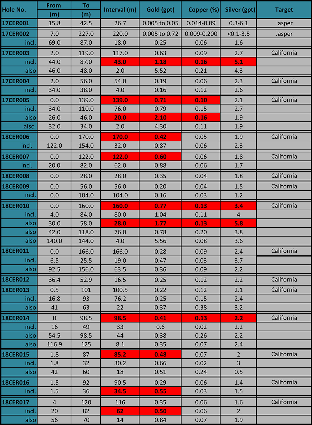
Table 2: Results of Phase 2 Core Drill program (2022):
| Table 3: 2022 Core Drill Hole Select Multi-Element Results with Gold |
| |
| Hole No. |
From |
To |
Interval |
Gold (gpT) |
Copper (%) |
Silver (gpT) |
Molybdenum (ppm) |
| |
m |
m |
m* |
|
|
|
|
| |
| CAL22-022 |
97.5 |
106.5 |
9 |
1.72 |
36m/0.069 |
36m/1.313 |
79.5m/38.15 |
| |
150 |
166.5 |
16.5 |
0.341 |
28.5m/0.21 |
28.5m/3.705 |
|
| |
| CAL22-023 |
12 |
40.5 |
28.5 |
0.537 |
4.5m/0.0857 |
33m/1.118 |
|
| |
81.7 |
89.2 |
7.5 |
0.429 |
7.5m/0.0743 |
7.5m/1.64 |
|
| |
| CAL22-024 |
0 |
48 |
48 |
0.444 |
49.5m/0.0521 |
51m/1.644 |
|
| |
75 |
81 |
6 |
0.247 |
|
4.5m/1.06 |
|
| |
| CAL22-025 |
0 |
9 |
9 |
0.203 |
90m/0.0658 |
48m/1.083 |
|
| |
51 |
63 |
12 |
0.26 |
|
|
|
| |
130.5 |
139.5 |
9 |
0.646 |
|
|
|
| |
|
|
|
|
|
|
160.5m/113 |
| |
| CAL22-026 |
0 |
213 |
|
|
|
|
210m/40 |
| |
| CAL22-027 |
0 |
120 |
120 |
0.677 |
99m/0.1812 |
154.5m/3.499 |
|
| |
| CAL22-028 |
49.5 |
54 |
4.5 |
0.545 |
|
1.5m/1.3 |
|
| |
226.5 |
235.5 |
9 |
0.442 |
|
1.5m/1.7 |
106.5 m/18 |
| |
| CAL22-029 |
48 |
54 |
6 |
0.277 |
1.5m/0.0623 |
10.5m/1.343 |
|
| |
130.5 |
187.5 |
57 |
0.773 |
54m/0.0681 |
39m/1.373 |
|
| |
| CAL22-030 |
75 |
82.5 |
7.5 |
0.315 |
18m/0.0817 |
18m/1.425 |
|
| |
115.5 |
121.5 |
6 |
0.544 |
|
16.5m/1.955 |
|
| |
| CAL22-031 |
0 |
135 |
135 |
0.564 |
|
|
|
| |
0 |
28.5 |
28.5 |
0.873 |
37.5m/0.0556 |
37.5m/2.615 |
|
| |
49.5 |
135 |
85.5 |
0.581 |
85.5m/0.0373 |
85.5m/1.946 |
|
To date, 1,183 soil samples have been collected spanning about 630 hectares with sample spacings from 25m to 200m. Robust gold in soil anomalies are found on California, Purisima East, Purisima West, and Jacobo: only the California target has been drill-tested. Gold in soil anomaly measures 700m by 700m covering Purisima East and coincides with large breccia bodies resembling diatremes with strong sericite and kaolinite alteration.
In early 2023 a detailed drill roadcut sampling and mapping program was conducted, with 779, 5 m chip channel samples collected and 1:200 scale mapping conducted over 4,600 m of roads. This surface program expanded the known extent of the altered porphyry system to now measuring approximately 1,000 meters E-W by 1,200 meters N-S and still open. The surface program better clarified the target geology including structure, lithologies, breccias, and alterations. A potential central potassic alteration zone was found zone in the northern extent of the surface program, suggesting more of the porphyry system is to be found beyond.
A 12.8km pole-dipole IP geophysical survey was completed in 2016 over 220 hectares covering portions of the California soil anomaly and the Jasper prospect. Strong chargeability anomalies starting from the surface to depths of at least 600m were outlined with values ranging from 5 to 80mrads and averaging 40-50mrads. Such broad, strong chargeability anomalies are often associated with large zones of disseminated sulfide mineralization typical of porphyry copper deposits. A 3-dimensional IP survey covering 520 hectares was conducted in 2019, extending the coverage from the 2016 survey towards the west and southwest covering 3 additional targets: Estrella, Purisima East, and Purisima West. Impressive and extensive IP anomalies were detected from near surface to depths of 500m on all three targets. Collectively, Aztec has 740 hectares of IP coverage on the project with open-ended anomalies confirming the extensive mineral potential.
A helicopter airborne magnetic-radiometric-VLF survey was completed in 2018, covering the entire property with 100-meter spaced lines flown at 40m altitude. The data show multiple magnetic highs spaced along the northern 1/3rd of the property, often coinciding with the identified targets. A large magnetic high sits under the California target, extending north and east, supporting the association of gold-copper with a magmatic source. A magnetic low is noticeable at California where the gold+/-copper mineralization was detected in the 2018 drilling.
QP Statement – Allen David Heyl, B.Sc., CPG., is the Qualified Person for Aztec and has reviewed and approved the technical disclosures contained herein.